Site Information Sheet
for nomination to join the East Asian-Australasian Shorebird Site Network |
| Osaka Nankou Bird Sanctuary (Japan) |
|
|
|
|
|
|
|
|
| PART 1 (Essential) |
|
|
|
|
|
|
|
|
|
|
|
|
|
|
|
|
| 1 |
Date: |
10 Mar. 2003 |
|
|
|
|
|
| 2 |
Country: |
Japan |
|
|
|
|
|
| 3 |
Name ofsite: |
Osaka Nankou Bird Sanctuary |
|
|
|
| 4 |
Geographical coordinates: |
Latitude 34°38' N, Longitude 135°38' E |
|
|
|
| 5 |
Altitude: |
DL -0.2~+1.6 m |
|
|
|
| 6 |
Area: |
19.3 ha (Wetland area: 12.8 ha, Peripheral planting area and observatories:6.5ha) |
|
|
|
|
|
| 7 |
Overview: |
|
Osaka Nankou Bird Sanctuary is in the northwest corner of Sakishima
landfill with about 1,000 ha area in Osaka Bay. West side of the sanctuary
faces the Osaka Bay through the sea bank. The climate of this area is temperate.
After the reclamation in 1933, shorebirds began to utilize this area, and
their numbers have increased gradually. In 1969, NGO actions began to conserve
this area as habitat for shorebirds. As the result of these actions, Osaka
City decided to build a bird park on the part of the landfill and it opened
in 1983. Now Osaka Nankou Bird Sanctuary plays a role as an important stopover
site, and is nominated as one of Japan's important wetlands by the Ministry
of the Environment.
|
|
|
| 8 |
Justification of Shorebird Site Network criteria: |
|
Osaka Nankou Bird Sanctuary meets the Network criteria in that |
|
|
1) Little Ringed Plover (Charadrius dubius) met the criteria > 1% in the south migrating period in 1997 and 2001 (See Table 1). |
|
2) and Kentish Plover (Charadrius alexandrinus), Red-necked Stint (Calidoris ruficollis) and Grey-tailed Tattler (Heteroscelus brevipes) met the staging criteria on several occasions (see Table 1). |
|
3) Spoon-billed Sandpiper (Eurynorhynchus pygmeus) (IUCN classified as
vulnerable - C1) and Spotted Greenshank (Tringa guttifer) (classified as
Endangered - C1) have been recorded.
|
|
|
|
| 9 |
Wetland Type: |
|
Human-made wetland - intertidal mud, sand or salt flats (G) and intertidal marshes (H). |
| 10 |
Outline map of site: |
Attached |
| 11 |
Jurisdiction: |
City of Osaka |
| 12 |
Management authority: |
|
|
Port and Harbour Bureau trusts the management of Osaka Nankou Bird Sanctuary to the Association for development of Osaka Bay. |
|
|
Hideo IGARASHI
the Director of Port and Harbour Bureau Osaka W.T.C Bldg. 41F., 1-14-16,
Nankou-kita, Suminoe-ku, Osaka 559-0034, Japan. |
|
| 13 |
Name and address of compiler: |
|
|
Hiroshi TAKADA
Secretary General, Nankou Group 96 of a local MGO in Osaka
4-14-804, Nankou-naka 3-chome, Suminoe-ku, Osaka 559-0033, Japan
|
|
|
|
| PART 2 (Optional: Additional Information) |
| 14 |
General Location: |
|
The site is located in the west part of Osaka City (area: 221.95km2, population:
2,619,243)which is the largest city in Osaka Prefecture. The west part
of the site faces the Osaka Bay which is a good fishing ground. The north
part of the site faces a sea route to the Osaka harbour. |
| 15 |
Physical features: |
|
| geology and geomorphology: |
|
tidal fla |
| origins: |
|
artificial |
| soil type and chemistry: |
|
spread sand, clayey soil |
| Water quality: |
|
pH: |
8.0-8.4 |
|
|
DO: |
6.6~13.2 mg/l |
|
|
COD: |
3.4~9.0 mg/l |
|
|
BOD: |
0.5~2.1 mg/l |
|
|
SS: |
3~15 mg/l |
| depth: |
|
2 m at maximum |
| tidal variations: |
|
M.S.L. +0.6~-1.3 m |
| catchment area: |
|
9 ha at average water level (DL+0.95 m) |
| climate: |
|
annual mean temperature: 17.2 degree C |
|
|
annual precipitation: 1,303 mm |
|
|
(average of Osaka City from 1997 to 2001) |
|
| 16 |
Hydrological values: |
|
|
The water level almost depends on the sea water level. There is no fresh
water inlet by river, fresh water inlet is only rain water. However, South
Pond (fresh water lake) is controlled by open/close of the Sluice Gate
when the fresh water level is rising (See attached Map 2). |
| 17 |
Ecological features: |
|
|
| 1)Benthos: |
|
|
| Over 100 species of benthos were identified by benthos research from 2000 to "2002. For example, |
| North tidal pool (sea water): |
|
Ruditapes philippinarum, Musculista senhousia, Cirriformia tentaculata,
Neanthes succinea, Capitellidae gen. Sp, Grandidierella japonica, Corophium
insidiosum,Carcinus mediterraneus, etc. |
| West tidal pool (sea water): |
|
|
Littorina brevicula, Reishia clavigera, Crassostrea gigas, Perinereis nunita,
Hemigrapsus sanguineus, Hemigrapsus penicillatus, etc. |
| South pond (flesh water): |
|
Chironomus salinarius, etc. |
| 2) Fish: |
|
|
Tridentiger obscurus, Luciogobius sp., Acanthogobiusflavimannus,Favonigobius
gymnauchen, Mugil cephalus cephalus, etc. |
| 3) Flora: |
|
|
|
Ulva spp., Gracilaria sp., Phragmites communis, etc. |
| 4) Utilization by birds: |
|
|
|
(1) The total number of species which identified at this site from 1983
to 2002 are 236 species, especially the total number of species of shorebird
are 51 species. |
|
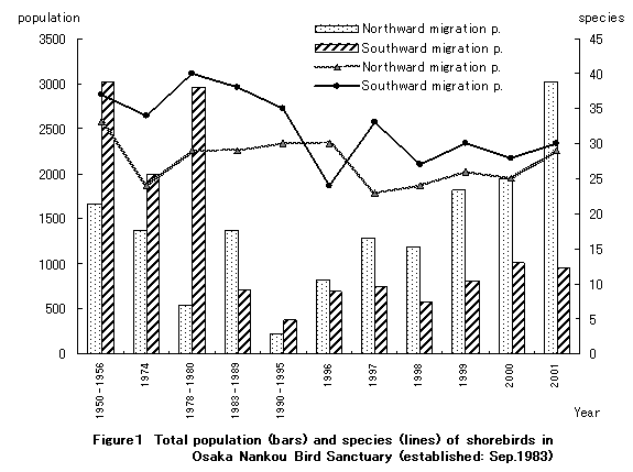
(2) Total population and species of shorebirds:
" See Figure 1 as bellows, |
|
 |
|
|
(3) dominant species: |
|
Charadrius alexandrinus, Calidris ruficollis, Calidris alpina, etc. "
"See Figure 2 as bellows |
|
 |
| 18 |
Noteworthy flora: |
|
Fimbristy ferruginea var. sieboldii (are designated as necessity watch
species in Osaka Red Data Book), Spergularia marina, Atriplex hastate,
Calystegia soldanella (are designated as necessity watch species in Osaka
Red Data Book), Typha latifolia, Carex
scabrifolia (are designated as necessity watch species in Osaka Red Data
Book)
|
| 19 |
Noteworthy fauna: |
|
Angustassiminea sp., Rapana venosa (are designated as vulnerable species
in WWF Japan Science Report, Vol. 3), Myya arenaria oonogai (are designated
as vulnerable species in WWF Japan Science Report, Vol. 3), Parasesarma
plicatum (are designated as near threatened species in WWF Japan Science
Report, Vol. 3), Uca (Celuca) lactealactea (are designated as vulnerable
species in WWF Japan Science Report, Vol. 3), "
Paratachys plagiatus shimosae |
| 20 |
Social and cultural values: |
|
1) landscape of view for sea |
|
2) the place for environmental education |
|
3) the place for wetland restoration |
| 21 |
Land tenure/ownership: |
|
|
|
| |
public-owned land |
|
|
|
| 22 |
Current land use: |
|
|
|
|
Proposed site: observation facilities, etc. |
|
|
|
|
Surrounding areas: |
|
|
|
|
fishing area, port and harbour facilities, business offices area, residential area, etc. |
| 23 |
Adverse factors affecting the ecological character of the site: |
|
1) increase alien species: Carcinus mediterraneus,Perna viridis,
etc. |
|
2) extreme overgrowth: Ulva spp., etc. |
|
3) effect to environment or bird by fisherman |
|
Tidal flat are contaminated by dust of fisherman's and wild-bird are also effected by
theirs especially fishing gut. |
| 24 |
Conservation measures taken: |
|
1) withdrawal Ulva spp. witch were extreme overgrowth. |
|
2) recover the topography of tidal flat |
|
3) pick up the waste which thrown by fisherman |
|
4) cut reeds |
|
5) designated for hunting reserve area |
| 25 |
Conservation measures proposed but not yet implemented: |
|
None |
| 26 |
Current scientific research and facilities: |
|
Scientific Research: |
|
| |
wild-bird census: |
1 or 2 times per every month |
|
shorebirds census: |
started from 1983, done on every spring, autumn and winter |
|
benthos research: |
started from 1983, done on 30 times per every year |
|
goby research: |
done on 2002 |
|
flora research: |
done on 1983, 1989, 1995, and 2001, 2002 |
|
insect research: |
done on 2000, 2001, 2002 |
|
|
Facilities: |
|
| |
sediment monitoring and water quality survey |
|
|
measurement of ground level |
|
|
topography of tidal flat survey |
|
|
environmental survey for modification of pure water reserve |
|
|
| 27 |
Current conservation education: |
|
1) Wetlands Environmental Education Lecture Course had been held on 9 March,
2002 |
|
2) School correspondence have been conducted environmental education activities
for local elementary school students with Migratory Shorebirds, The Globe
Trotter. |
|
3) Short course of study Wetlands or bird-watching events have been held
for citizens. |
| 28 |
Current recreation and tourism: |
|
The total number of tourists are around 100,000 per annual years. Observant
events are held every Sunday and public holidays by volunteer staff, and
Osaka Branch of the Wild
Bird Society of Japan conducts bird-watching events every 4th Sunday of
each month. And also the Bird-weeks bird-watching for citizens are held
by Port and Harbour Bureau,City of Osaka with supportable NGO's staff on
every May. |
| 29 |
References: |
|
1) Try to attract Bird Sanctuary at Osaka Bay -17 years history of Conserve
Wild Bird
Society of Osaka Nankou-/ 1985/ Conserve Wild Bird Society of Osaka Nankou |
|
2) 500 Important Wetlands in Japan/ 2001/ Nature Conservation Bureau,
Ministry of"the Environment, Japan |
|
3) Wildbirds Inventory of Osaka, 2001/ 2002/ Osaka Branch of the
Wild Bird Society of Japan |
|
4) Osaka Red Data Book 2000/ 2000/ Environment, Agriculture, Forestry
and Fisheries Department, Osaka |
|
5) Guidebook of Osaka Nankou Bird Sanctuary/ 1988/ Development and Technical
Association of Osaka Bay |
|
6) The Interim Report of the Shorebirds Census in Japan ?winter of 1999,
spring,autumn and winter of 2001, spring, autumn and winter of 2002/ 2000-2002/
Nature Conservation Bureau, Ministry of the Environment, Japan, WWF Japan |
|
8) Migratory Shorebirds, The Globe Trotter/ 2001/ Ministry of the Environment,
Japan, WWF Japan, US Fish and Wildlife Service
|
| 30 |
List of attachment: |
|
| |
Map 1: Overall location map of the site (scale : 1:25,000)"
Map 2: Detailed map of the site Photos
Table 1: Table of Census Records of Proposed Site
Table 3: Record of sightings of leg-flagged shorebirds in Osaka Nankou Bird Sanctuary
from 1996 to 2002
Appendix 1: 1950-2002 Shorebird Surveys in Osaka Nankou Bird Sanctuary
The aggregate total of species' peak counts in northward migration
period (March to May)-
Appendix 2: 1950 - 2002 Shorebird Surveys in Osaka Nankou Bird Sanctuary
The aggregate total of species'
peak counts in southward migration
period (late July to early November)- |
|